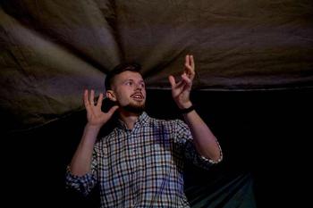
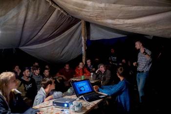
Over 1,500 years ago the current territory of our region was home to the ancestors of Slavic peoples. The remains of their settlements are now hidden by several layers of soil. Studying ancient history, however, does not mean moving backwards. On the contrary, it helps to develop modern technologies. How is it possible? Researcher and lecturer at the Department of Geoecology and Environmental Monitoring of the Faculty of Geography, Geoecology, and Tourism, Dmitry Sarychev, who heads the project of the Russian Geographical Society “Search for early Slavic archaeological sites in the Don basin using geo-information technologies and artificial intelligence”, together with his colleagues teaches artificial neural networks to search for ancient sites and thus contribute to archaeological studies. On Archaeologist’s Day, 15 August, and just before the Geographer's Day, 18 August, we published an interview with Dmitry Sarychev taken by a 3rd year student of the Faculty of Romance and Germanic Philology Alena Cherevatyuk about the joint project by the Russian Geographical Society and the Faculty of Geography, Geoecology, and Tourism.
What are you currently working on?
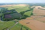
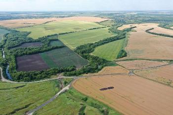
We are now teaching artificial intelligence (AI) to search for potential sites of ancient settlements in the so-called Upper Don Region. It’s a large territory which includes parts of the Voronezh, Lipetsk, Orlyol, Kursk, Tula, Ryazan, and Tambov Regions. It requires a lot of time and effort from professional archaeologists to study every meter of such a large territory. So AI is of great help, namely one of the most advanced technologies – deep neural networks. A convolutional neural network can analyse the already discovered settlement sites of ancient people considering the environment and determine the dependence between the location of the settlement and the landscape. It will then search for similar locations on the map, thus providing the archaeologists with several dozens of specific places, which can be studied in a couple of months. But in order to do this, the neural network has to be trained first, so we prepared two unique datasets for this. The first set includes detailed digital topographic maps with information about the rock bedding, the microclimate, the hydrographic network, and the soils in the Upper Don Region. The second set includes the coordinates of the early Slavic settlements found by archaeologists on this territory.
Why did you decide to search for early Slavic archaeological sites?
The term “early Slavic” is rarely used to talk about archaeological cultures and sites, so I would like to clear this up first. “Early Slavic” is used to define groups of people who apparently were the ancestors of Slavic peoples. There were two major historical and cultural communities, which lived in this territory in the III–Vth centuries. The remains of their settlements can be attributed either to the Kashyrki-Sedelka type (the time of the Later Roman Empire) and the Chertovitskoye-Zamyatino type (the time of the Huns). At the moment, over 200 such sites have been discovered on the studied territory. However, archaeologists estimate it to be just about half of the total number, which means there are 200 more ancient settlements to discover! It is a very intriguing and ambitious task for any scientists, and we hope that the latest information technologies will help us to complete it, or at least partially complete.
You use geoinformation technologies and artificial intelligence in your studies. This is an innovative approach to archaeology. Could you tell us a bit about the equipment you use in your research?
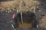
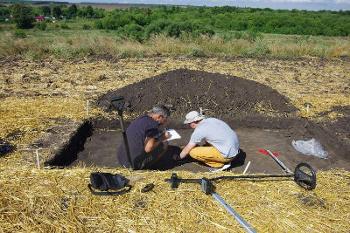
As far as we know, we (I mean the researchers working on the project) were indeed the first in Russia to perform what is called “predictive modelling of archaeological sites” and describe this method in our articles. Simply speaking, we search for archaeological sites using AI based on MaxEnt and MRCNN algorithms. We use geoinformation systems to prepare data for the training of the AI. Namely, we use GIS software with thematic maps, multispectral and radar satellite images, digital landscape models, and coordinates of the known archaeological sites of the studied period. During this stage, our main tools are very powerful computers. After the modelling is complete, we start searching for the archaeological sites in specific locations, and what we need now is just our eyes and shovels. If we manage to find an ancient settlement, we register its coordinates with a GNSS receiver - a special geodetic instrument which is similar to the GPS in our smartphones, only it is much more precise.
Would it be right to say that you work more with equipment rather than with actual archaeological findings?
We work with both. Our team includes professional archaeologists with over 20 years of experience, as well as geographers, specialists in geoinformatics, and programmers. We hope that such an interdisciplinary partnership will help us make new discoveries.
What stage are you at now?
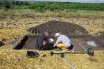
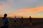
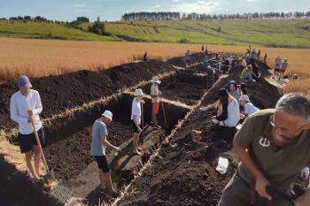
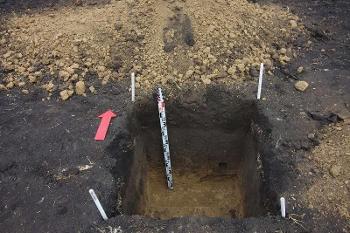
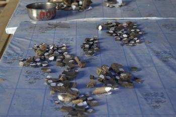
Our neural network can predict the most likely locations of early Slavic settlements, and we are now organising an expedition to study these locations. It will be autumn soon, the harvest time. After that, most fields will be ploughed up for winter crops and left to rest. This is the best time for archaeological excavations in our region. The plough exposes cultural layers and brings up elements of the material culture (mainly pieces of ceramics) which can help to locate settlements and determine their age. We are now preparing all the documents and acquiring permissions to begin our field study. Archaeological exploration is the most exciting and, if I may say so, romantic part of the project. It’s like treasure hunting.

What is the purpose of your study? Is there any hypothesis you want to prove? Or do you hope to find anything specific?
The official purpose of the project is to determine the most likely locations of the early Slavic settlements of the III–Vth centuries in the basin of the Upper Don based on paleogeographic data using GIS technologies and AI. If we find archaeological sites, we can preserve and study them. The results of the project should provide the authorities, land owners, and developers with information about any archaeological sites within their territory so that they can plan their activities within the framework of the federal law “On objects of cultural heritage of the peoples of the Russian Federation”. In other words, the results of our project should be of practical use. The aim is to preserve the historical and archaeological heritage of the region and protect it from destruction during construction works or deliberate criminal activity.
How did you manage to get the support of the Russian Geographical Society?
The Russian Geographical Society holds a competition for grants for basic and applied research. They support projects which are of great social significance and can bring practical results beneficial for the country and its regions. We submitted an application for the competition and our project was chosen among the best ones. This is how we obtained our financing. We are very grateful to the Russian Geographical Society for this grant.
In conclusion, I’d like to say that our project has just started. We will be glad to show university and school students the specifics of archaeological exploration, and we encourage them to contribute to the studies of the history of their homeland. If you are interested in geography and history of your homeland and would like to participate in the project of the Russian Geographical Society, please contact Dmitry Sarychev at sarychev.geo@gmail.com.
Photo from the page on VK
“’Search’: archaeology and ethnography of Slavic people”